FIGURE 7.26 Daytime development of the valley breeze circulation system. Image Copyright: Michael Pidwirny.
Thermal Circulations
As discussed in previous sections, winds occur due to variations in atmospheric pressure. Pressure gradients may develop on a local to a global scale because of differences in the heating and cooling of the Earth's surface. Heating and cooling cycles that develop daily or annually can give rise to several common local or regional thermal wind systems. The basic circulation system that develops is described in Figure 7.23.
In this first diagram (A - Figure 7.23), there is no horizontal temperature or pressure gradient and, therefore, no wind. Atmospheric pressure decreases with altitude, as depicted by the drawn isobars (1000 to 980 mb). In the second diagram (B - Figure 7.23), the potential for solar heating is added, which creates contrasting surface areas of temperature and atmospheric pressure. The area to the right receives more solar radiation, and the air begins to warm from heat energy transferred from the ground through conduction and convection. The vertical distance between the isobars increases as the air rises. To the far left, less radiation is received due to clouds, and this area is relatively cooler than the area to the right. In the upper atmosphere, a pressure gradient begins to form due to rising air and the upward spreading of isobars. The air then begins to flow in the upper atmosphere from high pressure to low pressure.
Diagram C (Figure 7.23) shows a fully developed thermal circulation system. Beneath the upper atmosphere high is a thermal low-pressure center created from the heating of the ground surface. Below the upper atmosphere low is a thermal high created by the relatively cooler air temperatures and the descending air from above. Surface air temperatures are cooler here because clouds block shortwave radiation from reaching the Earth's surface. At the surface, the wind blows from high to low pressure. Once at the low, the wind rises into the upper air high-pressure system due to thermal buoyancy and upper-atmosphere outflow. From the upper high, the air travels to the upper low, then back down to the surface high, completing the circulation cell. Note that the thermal circulation cell is a closed system that redistributes air from areas with a surplus to areas with a deficit (in terms of air pressure). This circulation cell is driven by the greater heating of the surface air on the right side of the diagram.
Sea and Land Breezes
Sea and land breezes are thermal circulation systems that develop at the interface of land and ocean or large bodies of water. At this interface, the dissimilar heating and cooling characteristics of land and water drive the development of an atmospheric pressure gradient, which causes air in these areas to flow. During the daytime, the land heats up much faster than water as it receives solar radiation from the Sun (Figure 7.24). The warmer air over the land then expands and rises, forming a thermal low. At the same time, the air over the ocean becomes a cool high because of the water's slower heating rate. The air begins to flow when there is a significant difference in air temperature and pressure across the land-to-sea gradient. The development of this pressure gradient causes the heavier, cooler air over the ocean to move toward the land and to replace the air rising in the thermal low. This localized airflow system is called a sea breeze. The sea breeze usually begins in midmorning and reaches its peak in the afternoon, when the greatest temperature and pressure contrasts occur. Sea breeze dies at sunset when air temperature and pressure become similar across the two surfaces.
At sunset, the land surface stops receiving radiation from the Sun (Figure 7.25). As the night continues, the land surface begins losing heat energy much faster than the water surface. After a few hours, air temperature and pressure contrasts develop between the land and ocean surfaces. The land surface, cooler than the water, becomes a thermal high-pressure area. The ocean becomes a warm thermal low. Wind flow now moves from the land to the open ocean. This type of localized airflow is called a land breeze.
Mountain and Valley Breezes
Mountain and valley breezes are common in regions with great topographic relief. Avalley breezedevelops during the day as the Sun heats the land surface and air at the valley bottom and sides (Figure 7.26). As the air warms, it becomes less dense and buoyant and begins to flow gently up the valley sides. Vertical ascent of the air rising along the sides of the mountain is usually limited by the presence of a temperature inversion layer. When the ascending air currents meet the inversion, they are forced to move horizontally and back down to the valley floor. This situation creates a self-contained circulation system. The rising air can condense and form cumuliform clouds if conditions are right.
At night, the air along mountain slopes cools quickly due to longwave radiation loss (Figure 7.27). As cooling continues through the night, the air at high elevations becomes denser and begins to flow downslope because of gravity, creating amountain breeze. Convergence of the draining air occurs at the valley floor, forcing it to move vertically upward. The upward movement is usually limited by a temperature inversion, which forces the air to begin moving horizontally. This horizontal movement completes the circulation cell system.
Katabatic Winds
Katabatic windsare a particular type of mountain breeze with relatively faster flow velocities. Katabatic winds develop under specific environmental conditions. These environmental conditions include the presence of an extensive elevated plateau and sufficient cooling of a large air mass by longwave radiation loss. Katabatic winds begin flowing when the developing pool of cold air becomes large enough to be influenced by gravity and topography. The flow stops when all the pooled cold air drains from the plateau to locations downslope. Some katabatic winds can accelerate rapidly when an air mass is forced to flow through narrow terrain. This type of acceleration process is known as aventuri effect.
Katabatic winds are widespread along the margins of Greenland and Antarctica's glacial ice sheets. Cape Denison, Antarctica, can experience katabatic winds reaching 200 kph (120 mph). This location also holds the record for the highest average wind speed on our planet.
Monsoon Winds
Monsoonsare continental-scale wind systems that change direction predictably with the seasons. Like land/sea breezes, these wind systems are created by the temperature contrasts between land and ocean surfaces. Monsoons are different from land/sea breezes both spatially and temporally. Monsoons occur over thousands of square kilometers and have an annual cycle.
During the summer, monsoon winds blow from the cooler ocean surfaces onto the warmer continents (Figure 7.28). In the summer, the continents become much warmer than the oceans because of several factors. These factors include:
- Specific heat differences between land and water.
- Greater evaporation over water surfaces.
- Subsurface mixing in ocean basins redistributes heat energy through a deeper layer.
Precipitation is typically associated with the summer monsoons (Figure 7.29). Onshore winds blowing inland from the warm ocean are very humid, and slight cooling of these air masses causes condensation and rain. In some cases, this precipitation is greatly intensified by orographic uplift. Some highland areas in Asia receive more than 10 m (33 ft) of rain during the summer months.
In winter, wind patterns reverse because the ocean surface is now warmer. With less solar energy available, the continents begin cooling rapidly as longwave radiation is emitted into space. The ocean surface retains heat energy longer because of water's high specific heat and subsurface mixing. The winter monsoons bring clear, dry weather and winds that flow from land to sea.
Figure 7.28 illustrates the general wind patterns associated with Asia's winter and summer monsoons. The Asiatic monsoon results from complex climatic interactions among land and water distribution, topography, and tropical and mid-latitude circulation. In the summer, a low-pressure center forms over northern India and Southeast Asia because of higher solar insolation. Warm, moist air is drawn into the thermal lows from air masses over the Indian Ocean. Summer heating also causes the development of a strong latitudinal pressure gradient and the development of an easterly jet stream at an altitude of about 15 km (9.3 mi) and a latitude of 25° North. The jet stream enhances rainfall in Southeast Asia, the Arabian Sea, and South Africa. When autumn returns to Asia, the thermal extremes between land and ocean decrease, and the Westerlies of the mid-latitudes move in. The easterly jet stream is replaced with strong westerly winds in the upper atmosphere. Subsidence from an upper-atmosphere cold low over the Himalayas produces outflow, creating a surface high-pressure system that dominates the weather in India and Southeast Asia. Monsoon wind systems also exist in Australia, Africa, South America, and North America.

FIGURE 7.23 Illustrated is the formation of a thermal circulation system. This process begins with the unequal heating of the Earth’s surface and lower atmosphere (A). The unequal heating causes the isobars over the heated area to spread apart because of convection and air expansion. This process also initiates horizontal airflow in the upper atmosphere (B). Airflow patterns then begin in the vertical and near the ground surface, completing the circulation system (C). Image Copyright: Michael Pidwirny.

FIGURE 7.24 Daytime development of the sea breeze circulation system. Image Copyright: Michael Pidwirny.

FIGURE 7.25 Night-time development of the land breeze circulation system. Image Copyright: Michael Pidwirny.


FIGURE 7.27 Night-time development of the mountain breeze circulation system. Image Copyright: Michael Pidwirny.

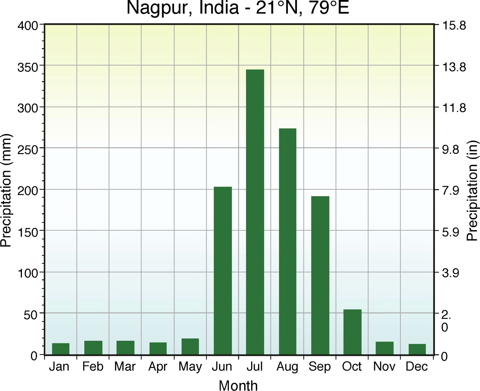
FIGURE 7.29 Monthly precipitation at Nagpur, India, shows a summer maximum enhanced by monsoon circulation. The summer monsoon draws warm, moist air from the Indian Ocean to Nagpur during June, July, August, and September. Image Copyright: Michael Pidwirny.
FIGURE 7.28 Summer and winter monsoon wind patterns for Southeast Asia. Winds blow from the Indian Ocean to the Asian landmass during the summer monsoon. The air over the Indian Ocean is warm and very moist. When this air reaches the continent, elevation changes cause precipitation because of orographic uplift. During the winter monsoon, the winds blow from the Asian continent to the oceans. This air is dry and stable. Image Copyright: Michael Pidwirny.