Air Masses
An air mass is a large body of air of relatively similar temperature and humidity characteristics, covering thousands of square kilometers. Typically, air masses are classified according to the characteristics of their source region or formation area. A source region can have one of four temperature attributes: equatorial, tropical, polar, or arctic. Air masses are also classified as continental or maritime based on moisture characteristics. Combining these two categories, several possibilities are commonly found associated with North America: maritime polar (mP), continental polar (cP), maritime tropical (mT), continental tropical (cT), and continental arctic (cA). Maritime tropical and continental tropical air masses often have the right temperature and moisture characteristics to produce thunderstorms. The following diagram (Figure 8.19) describes the source regions and familiar movement patterns for the various types of air masses associated with North America.
Transitional Fronts
Frequently, two air masses develop a sharp boundary, or interface, where the temperature difference between them becomes intensified. Such an area of intensification is called a frontal zone or a front. The boundary between the warm and cold air masses always slopes upwards over the cold air. This situation occurs because cold air is much denser than warm air. The sloping of warm air over the cold air leads to a forced uplifting (frontal lifting) of the warm air if one air mass moves toward the other. This uplifting can cause condensation or deposition to occur and the possibility of precipitation along the frontal boundary.
Frontal zones where the air masses are not moving against each other are called stationary fronts. Cold or warm fronts can develop in transitional areas with some air mass movement. Figure 8.20 illustrates a vertical cross-section of a cold front. A cold front is the transition zone in the atmosphere where an advancing cold, dry stable air mass displaces a warm, moist unstable subtropical air mass. The cold front is drawn as a solid blue line with triangles on a weather map. The position of the triangles indicate the direction of frontal movement. Cold fronts move between 15 and 50 kph (9 and 31 mph) in a southeast-to-east direction. High-altitude cirrus clouds are found well before the cold front. Above the surface location of the cold front, high-altitude cirrostratus and middle-altitude altocumulus are common. Precipitation is commonly found just behind the front, where frontal lifting has caused the development ofcumulusandtowering cumulonimbus clouds. Table 8.3 describes some of the weather associated with a cold front.
A warm front is illustrated in the cross-section diagram found in Figure 8.21. A warm front is the transition zone in the atmosphere where an advancing warm subtropical, moist air mass replaces a retreating cold and dry, polar air mass. On a weather map, a warm front is drawn as a solid red line with half-circles. The position of the half-circles shows the direction of frontal movement. Warm fronts move about 10 kph (6 mph) in a northeast direction. This rate of travel is less than half the speed of a cold front. Gradual frontal lifting ahead of the frontal zone leads to cloud formation and precipitation. High-altitude cirrus, cirrostratus, and middle-altitude altostratus clouds are found well before the front. About 600 km (375 mi) ahead of the front, nimbostratus clouds occur. These clouds produce precipitation as snow or rain. Between the nimbostratus clouds and the surface location of the warm front, low-altitude stratus clouds are found. Finally, a few hundred kilometers (a few hundred miles) behind the front, scattered stratocumulus are common in the lower troposphere. Table 8.4 describes some of the weather associated with a warm front.
Occluded fronts are produced when a fast-moving cold front catches and overtakes a slower-moving warm front. Two types of occluded fronts are generally recognized. A cold type occluded front occurs when the air behind the front is colder than the air ahead. When the air behind the front is warmer than the air ahead, a warm occluded front forms. Warm type occlusions are common on the West coast of continents and generally form when maritime polar air collides with continental polar or arctic air. The cross-sectional diagram in Figure 8.22 illustrates a cold-type occlusion. During the occlusion process, the invading, mild, moist air behind the warm front has been lifted into the upper troposphere.
Finally, the air mass and frontal systems described in this section are often associated with a storm system known as a mid-latitude cyclone. The following section will describe this weather system in detail.

FIGURE 8.19 Source sites and movement patterns for North America's major air masses. Image Copyright: Michael Pidwirny.

FIGURE 8.20 Atmospheric cross-section of a cold front. Image Copyright: Michael Pidwirny.
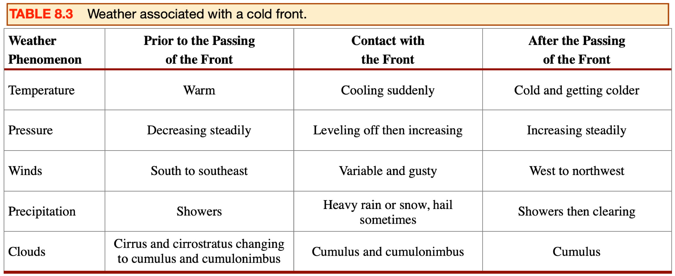

FIGURE 8.21 Atmospheric cross-section of a cold front. Image Copyright: Michael Pidwirny.

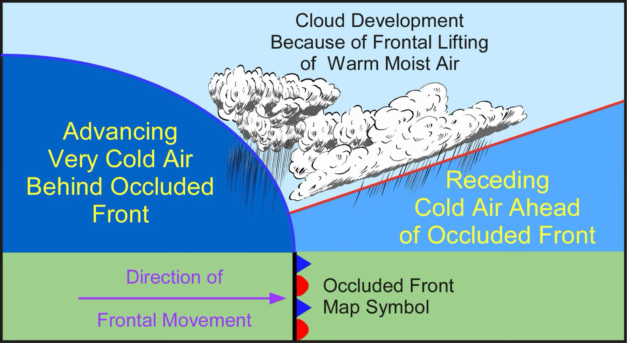
FIGURE 8.22 Atmospheric cross-section of an occluded front. Image Copyright: Michael Pidwirny.